Why can you see tomorrow from Alaska?
Short answer: From Little Diomede, an Alaskan island in the Bering Strait, you can see Big Diomede in Russia, about 2.4 miles away. The International Date Line runs between them, so Big Diomede is almost a full day ahead. That is why it is nicknamed Tomorrow Island.
Two islands, two countries
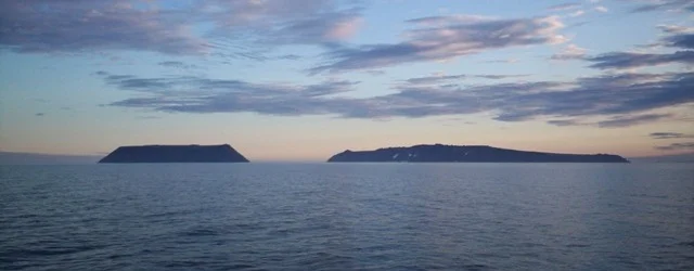
In the middle of the Bering Strait, between Alaska and Russia, sit two small islands. Little Diomede belongs to the United States and is part of Alaska. Big Diomede belongs to Russia. At their closest points the two are about 2.4 miles (3.8 km) apart. Big Diomede is in view from Little Diomede, so from this corner of Alaska you can see Russia.
The border between the two countries runs through the water between them. In that stretch of sea the border also serves as the International Date Line. The line runs about 1.2 miles (2 km) from each island, at 168°58'37" west.
What the date line does
The International Date Line is where the calendar changes. NOAA sums up the rule: cross to the west "and it's one day later; cross back and you've 'gone back in time.'" The line runs roughly from pole to pole through the Pacific, but it zigzags around political borders, including eastern Russia and Alaska's Aleutian Islands.
That rule puts the Diomedes on opposite sides of the calendar. Big Diomede lies west of the line, so its date is one day later. When it is Monday on Little Diomede, it is usually already Tuesday on the island across the water.
Almost a full day apart
Each island keeps the time of its own country, so the gap is close to a full day. Wikipedia gives it as 21 hours, or 20 in summer. Not every account agrees: Amusing Planet says 23 hours. Either way, Big Diomede is almost a day ahead.
That is where the nicknames come from. Big Diomede is called Tomorrow Island and Little Diomede is called Yesterday Island.
Who lives on the islands
Little Diomede has a small village. It had 77 residents in 2023. Big Diomede has no civilian population. Its Inuit residents were resettled in coastal villages of Chukotka on the Russian mainland, and the island is now inhabited only by military units. Explorersweb describes it in 1987 as a top-secret Soviet military base, with soldiers and radar.
The swim into tomorrow
In August 1987 the American swimmer Lynne Cox swam from Little Diomede to Big Diomede, which was then Soviet territory. History.com calls it the first recorded swim from the United States to the Soviet Union. The National Park Service gives the water temperature as 38°F, about 3°C.
Fog cut visibility to about 400 meters, Explorersweb writes, and Cox was afraid she would miss the island. She swam an extra 800 meters and reached the sharp rocks of the shore so tired that she could not pull herself up. Accounts of her time in the water range from 2 hours 5 minutes (National Park Service) to 2 hours 16 minutes (History.com). Mikhail Gorbachev and Ronald Reagan both congratulated her.
Halfway across she passed the date line. She left one day behind on the American island and came ashore in the next one.
Walking to tomorrow
For half the year the gap is ice. The Bering Strait is generally frozen from mid-December to mid-June. Under the right winter conditions, an ice bridge spans the gap between the islands. Locals on Little Diomede once carved a runway into the ice sheet, but thinning winter ice has since ended flights there.
People have crossed it on foot. Explorersweb reports that Dennis Schmitt walked from Little Diomede to Big Diomede in 1965, at 19, without being picked up by Soviet radar. There were also contacts in the 1970s with former residents of Big Diomede who walked across the strait to trade.
The border still runs through the strait, and so does the date line. Stand on Little Diomede and look west: the island on the horizon is already in tomorrow.
FAQ
How far apart are Little Diomede and Big Diomede?
About 2.4 miles (3.8 km) at their closest points. Little Diomede belongs to the United States (Alaska) and Big Diomede to Russia.
How many hours ahead is Big Diomede?
Wikipedia gives 21 hours, or 20 in summer, because each island keeps its own country's time. Some accounts give other figures, such as 23 hours. Either way it is almost a full day.
Why is Big Diomede called Tomorrow Island?
It lies west of the International Date Line, where the date is one day later than on Little Diomede. Little Diomede is nicknamed Yesterday Island.
Has anyone swum between the Diomede Islands?
Yes. In August 1987 Lynne Cox swam from Little Diomede to Big Diomede in water of about 38°F (3°C). It took her a little over two hours.
Can you walk between the islands in winter?
The Bering Strait is generally frozen from mid-December to mid-June, and under the right conditions an ice bridge forms between the islands. Dennis Schmitt crossed on foot in 1965. Today the strait is a border between the United States and Russia.
Sources
- Wikipedia: Diomede Islands
- Wikipedia: Little Diomede Island
- NOAA Ocean Service: What is the International Date Line?
- National Park Service: Lynne Cox
- History.com: Lynne Cox swims into Communist territory (August 7, 1987)
- Explorersweb: 35 years ago today, Lynne Cox's world-changing swim across the Bering Strait
- Amusing Planet: Diomede Islands, two islands split by the US-Russian border and the International Date Line (2014)